Introduction
As urban areas expand and cities evolve into smart metropolises, the integration of advanced technologies becomes crucial for effective urban planning. Drone-based GIS (Geographic Information Systems) and topographical surveys are playing a pivotal role in shaping the future of smart cities. This article explores how drones are transforming urban planning and smart city development through enhanced precision and innovative approaches.
What Are Drone GIS Surveys?https://millmanland.com/company-news/drone-surveying/
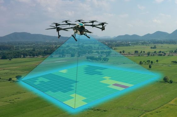
Drone GIS surveys utilize unmanned aerial vehicles (UAVs) to collect geospatial data that is integrated into Geographic Information Systems. These surveys offer numerous benefits for urban planning:
- High-Resolution Data: Drones capture detailed aerial imagery that can be processed into high-resolution maps and 3D models.
- Accurate Mapping: GIS data from drones provides precise location and elevation details, crucial for planning infrastructure and urban development.
- Efficient Data Collection: Drones can cover large areas quickly, reducing the time and cost compared to traditional surveying methods.
How Do Topographical Surveys Enhance Smart City Development?
Topographical surveys are essential for understanding the physical features of an area, and drones offer advanced capabilities for this process:
- Detailed Terrain Analysis: Drones provide accurate data on land contours, elevations, and features, which is vital for planning roads, buildings, and green spaces.
- Dynamic Mapping: The ability to frequently update topographical maps allows for adaptive planning and real-time monitoring of urban changes.
- Integration with Smart Technologies: Drones can collect data that integrates seamlessly with other smart city technologies, such as traffic management systems and environmental monitoring.
Benefits of Drone-Based Surveys for Urban Planninghttps://afconesinfra.in/our-sectors/
Incorporating drone-based surveys into urban planning offers several key advantages:
- Enhanced Precision: Drones provide precise measurements and high-resolution imagery, allowing for accurate planning and design.
- Cost Efficiency: By reducing the need for manual surveys and minimizing data collection errors, drones help lower project costs.
- Improved Decision-Making: Real-time data and detailed visualizations support better decision-making and strategic planning.
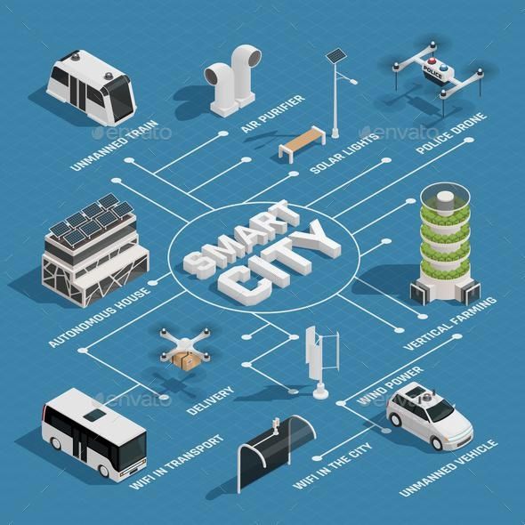
The Role of Drones in Smart City Development
Smart cities leverage technology to improve the quality of life for their residents. Drones contribute significantly to this vision:
- Infrastructure Monitoring: Drones can perform regular inspections of infrastructure such as roads, bridges, and utilities, ensuring they meet safety standards.
- Environmental Management: Drones help monitor environmental conditions, track pollution levels, and support sustainability initiatives.
- Urban Mobility: Data from drone surveys can enhance traffic management systems, optimize public transportation routes, and improve pedestrian pathways.

Government Guidelines and Smart City Initiativeshttps://smartcities.gov.in/guidelines
To align with current regulations and best practices, consider referring to government guidelines and smart city frameworks. For instance:
- Smart Cities Mission: This initiative provides guidelines and resources for developing smart city projects in India.
- U.S. Smart Cities Initiative: A comprehensive program offering resources and guidelines for smart city development in the United States.
High-Resolution Images and Maps
Incorporating high-resolution images and maps from drone surveys can significantly enhance the visual appeal and informativeness of urban planning documents. These visuals provide clear insights into land use, infrastructure development, and city layouts.

Call to Action: Partnering for Smart City Projects
If you’re looking to leverage drone technology for urban planning or smart city development, consider consulting with experts in the field. Partnering with a specialized firm can help you integrate drone-based GIS and topographical surveys into your projects, ensuring precision and innovation.
Contact us today to explore how drone technology can transform your urban planning and smart city initiatives.
Meta Description: “Discover the critical role of drone-based GIS and topographical surveys in urban planning and smart city development, driving precision and innovation.