Introduction
In the modern landscape of civil engineering, 3D scanning has emerged as a game-changer. At Afcones Infratech Pvt. Ltd, we leverage this innovative technology to enhance data collection and improve project outcomes. This blog explores the fundamentals of 3D scanning, its applications, benefits, and how it shapes the future of civil surveys.
What is 3D Scanning?
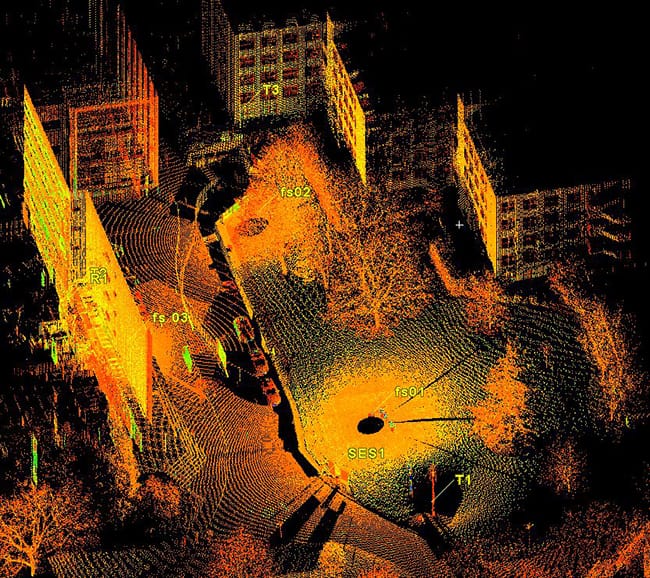
3D scanning involves capturing the physical dimensions and shapes of objects or environments using laser technology or photogrammetry. This process generates a highly accurate 3D model, often referred to as a point cloud, which provides valuable data for analysis and planning.
How 3D Scanning Works
- Data Capture: The scanning device emits laser beams or takes images from multiple angles. Each point captures precise coordinates.
- Point Cloud Creation: The data collected forms a dense cloud of points representing the scanned object or environment.
- Model Generation: Software processes the point cloud to create a 3D model that can be used for analysis, design, and visualization.
Key Technologies in 3D Scanning
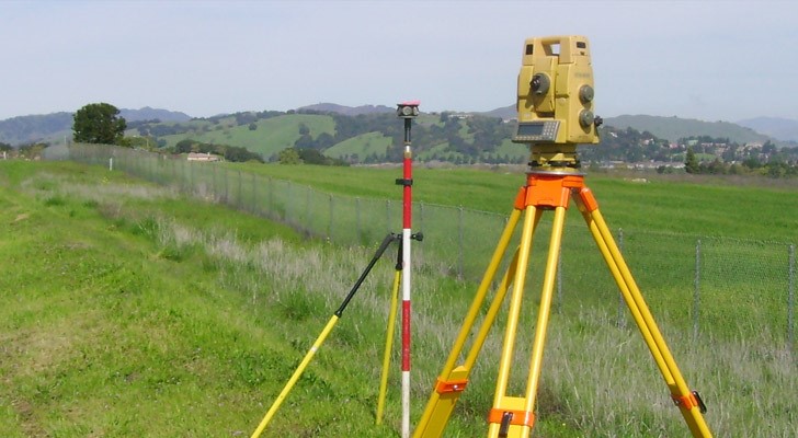
- Laser Scanners: These devices use lasers to measure distances and create detailed 3D representations of structures.
- Photogrammetry: This technique involves taking multiple photographs from different angles and using software to stitch them into a 3D model.
- Terrestrial and Aerial Scanning: Depending on the project, surveyors can use ground-based scanners or drones for aerial views.
Applications of 3D Scanning in Civil Surveys
1. Infrastructure Assessment
3D scanning provides detailed assessments of existing structures. Engineers can identify potential issues, such as cracks or deformations, with high accuracy.
2. Topographical Mapping
Surveyors use 3D scanning to create accurate topographical maps. This data assists in planning and designing projects, ensuring compliance with regulatory requirements.
3. Historical Preservation
In preserving historical sites, 3D scanning captures detailed measurements of structures. This data allows for accurate restorations and digital archiving.
4. Construction Monitoring
Throughout construction, 3D scanning enables project managers to monitor progress and compare it with the original plans. This approach helps maintain quality and identify discrepancies early.
5. Environmental Studies
3D scanning assists in environmental assessments by providing precise data on terrain and vegetation. This information is crucial for impact studies and planning sustainable developments.
Benefits of 3D Scanning
- High Accuracy 3D scanning delivers exceptional accuracy, capturing fine details that traditional surveying methods might miss.
- Time Efficiency The speed of data collection significantly reduces the time spent on surveys. Surveyors can cover large areas quickly and efficiently.
- Cost-Effectiveness Although the initial investment may be substantial, the long-term savings from reduced labor and rework make 3D scanning a cost-effective solution.
- Comprehensive Data The technology captures a wealth of data in one survey, providing more information for analysis and decision-making.
- Enhanced Collaboration 3D models facilitate better communication among project stakeholders, allowing for informed discussions and decisions.
Challenges of 3D Scanning
While 3D scanning offers numerous benefits, it also presents challenges:
- Initial Costs The equipment and software can require a significant initial investment. Companies must weigh these costs against potential benefits.
- Data Management The volume of data generated can be overwhelming. Implementing effective data management systems is essential for storing and analyzing information.
- Technical Skills Required Operating advanced scanning equipment demands specialized training. Organizations must ensure that staff possess the necessary skills.
- Environmental Limitations Certain conditions, such as heavy rain or fog, can affect the quality of data collected by laser scanners.
Future Trends in 3D Scanning
- Integration with BIM The integration of 3D scanning with Building Information Modeling (BIM) will enhance project planning and execution, leading to better coordination and collaboration.
- Increased Use of Drones Drones equipped with 3D scanning technology will continue to gain popularity for surveying large or hard-to-reach areas.
- Advancements in Software Ongoing improvements in processing software will make it easier to analyze and utilize 3D data, enhancing overall efficiency.
- Mobile Scanning Solutions Portable scanning devices will increase accessibility, allowing surveyors to perform scans in a variety of environments without extensive setups.
Case Studies
Case Study 1: Infrastructure Assessment
In a recent project, we used 3D scanning to assess the condition of a bridge. The detailed point cloud allowed engineers to identify structural weaknesses, leading to timely repairs and enhanced safety.
Case Study 2: Historical Preservation
For a historical site, we employed 3D scanning to create a digital archive of the structure. This data not only supports restoration efforts but also serves educational purposes for future generations.
Conclusion
At Afcones Infratech Pvt. Ltd, we believe that 3D scanning is a transformative technology in civil surveys. By harnessing its power, we enhance accuracy, efficiency, and collaboration in our projects. As we continue to explore innovative solutions, we remain committed to delivering exceptional results for our clients.